The 2003 Storm Chesapeake Sailors May Never Forget
SpinSheet co-founder David Gendell wrote this story for the 10-year anniversary of Hurricane Isabel. His words, especially those about how Chesapeake sailors will remember the Isabel storm surge, still ring true today, at the 20-year mark of this historic September storm.
There is a history of poorly forecast hurricanes pushing onto the Atlantic coast with deadly results. The Chesapeake/Potomac Hurricane of 1933 produced a 12-foot rise of the Potomac at Alexandria and swept a train of the tracks and into the Anacostica River, killing 10 people. In the northeast, the New England Hurricane of 1938 is referred to in hushed tones and recountings typically include details of the unsuspecting boaters and beachgoers who were surprised as the first dark clouds appeared on the horizon. Those clouds were the leading edge of a historic hurricane, and more than 600 New Englanders were killed that day.
There was a time—the half-century between the historic storms of the 1930s and the late 1980s—when the forecasts for tropical events were recited on scratchy VHF forecasts and interested parties scrawled the listed coordinates and penciled them onto charts, interpreting and forecasting for themselves.
This work was professionally augmented by the National Hurricane Center who sent reconnaissance planes into tropical features and issued warnings and forecasts that were mentioned on the six o’clock news and reprinted in newspapers. Soon, The Weather Channel dedicated a slice of each hour, at 50 minutes past the hour, to the Tropical Forecast and in the approach of a storm, sent camera crews to the impacted geographies. The resulting flow of information was not completely unfiltered, but the concept of a “sneak up on us” tropical event was no longer viable.
Although the information was more readily available, it was still up to individuals and organizations to take responsibility for preparations. In some cases the abundance of information leads to complacency. In other cases, unpreparedness can rule the day and can produce outcomes ranging from embarassing to destructive.
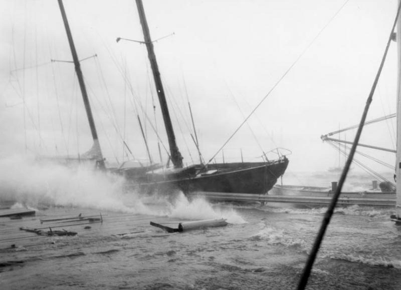
In October 1954, Hurricane Hazel gained strength and made a series of wobbles and turns before making landfall to the south of the mouth of the Chesapeake Bay. In Annapolis, 90 mile-per-hour winds from the eastern quadrant created havoc. The historic 72-foot ketch Vamarie, past winner of the Newport to Bermuda Race and, since 1936, in the care of the U.S. Naval Academy, was moored just off the Academy’s seawall, a position to windward of the rocks in the forecast easterly. Sadly, and perhaps predictably, Vamarie’s mooring chain parted, and she was repeatedly and very publicly pummeled to splinters on the seawall. The remains were hauled and she was broken up and disposed of the following year.
By mid-2003, access to the Internet was widely available. Web content was consumed with gusto, either via dial-up modems or via the faster and increasingly popular broadband solutions. Internet users of the era who could tear themselves away from MySpace, HotOrNot.com, and the Drudge Report found a trove of meteorological information from government, academic, and commercial sources. The old mysteries arounnd hurricane data dissemination and access to forecasts were gone forever.. Anyone could become a semi-pro hurricane tracker with access to the raw data and dozens of academic and government models. A constant river of raw data and professional forecasts now freely flowed across our screens.
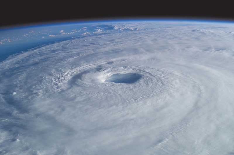
Isabel’s Projected Path
In September 2003, with the data and access unlocked, Isabel was not a surprise.
Those paying close attention to these things first made notice of the tropical event as early as September 6, nearly two full weeks before she impacted the Chesapeake Bay. On that day a wave off the Cape Verde Islands formed into a Tropical Depression and was named Isabel. By September 11, the storm had spun into a powerful Category 5 event, and models began aligning. The multicolored digital strings, each representing a projected path and carefully produced in labs around the perimeter of the Atlantic Basin, all brought Isabel ashore in the Mid-Atlantic. An alarming number of projections took her straight up the Chesapeake Bay. The approaching storm had our attention.
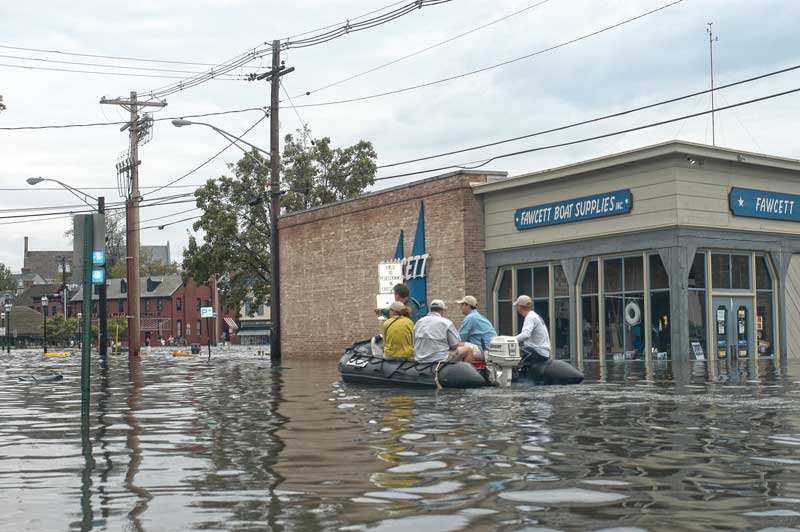
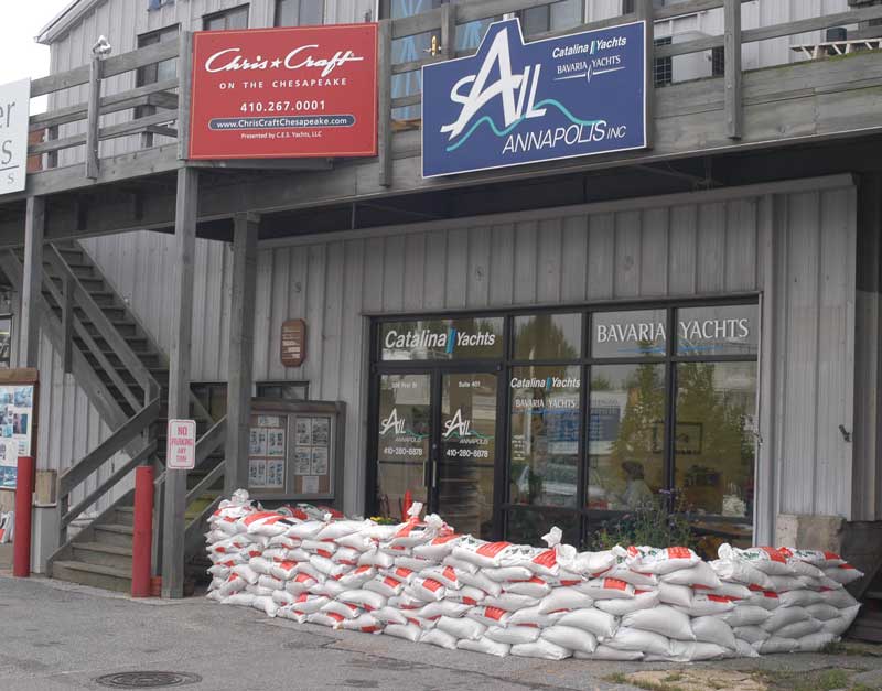
Along the waterfront, the community prepared. Boats were hauled, sandbags filled, lines secured. As we waited, I popped into Fawcett on the Annapolis City Dock where the crew, always enthusiastic and as seaworthy as they come, were preparing their facility for the possibility of rising waters.
A few days out, the projected tracks slowly and confidently slid south, and it became clear that the Chesapeake region would be spared widespread, catastrophic storm damage of a direct hit. The somewhat weakened storm would push ashore in the Carolinas and pass west of the Bay.
However, even in the face of this dampened forecast there was still risk, especially from rising waters. Maryland Governor Ehrlich issued an Emergency Declaration on the evening of September 16. In Hampton Roads, the Navy moved 40 ships out to sea. In Annapolis, the Academy hauled some vessels and moved many others up the Severn River to established “Hurricane Hole” moorings on protected deep-water creeks.
Landfall and the Rising Tide
Isabel made landfall in early afternoon on September 18 between Cape Lookout and Ocracoke Inlet, NC, bringing with her heavy rains and 105 mile per-hour winds. There was significant damage along her track, and she was directly responsible for 17 deaths, primarily from drowning or trauma sustained by falling trees or limbs. Isabel was indirectly responsible for 34 additional deaths primarily due to carbon monoxide poisoning due to inadequately ventilated generators
Inland Virginia was especially hit hard by the body of the storm and up to 20 inches of rain was recorded in some spots. When the storm finally arrived in Chesapeake Country, it brought wind and rain, but nothing extraordinary. The power went out across a large region, as it always does in these things. In Annapolis, it cut just before 11 p.m. By the time Isabel reached Annapolis’s latitude, its center was well-inland and it had been downgraded to a tropical storm.
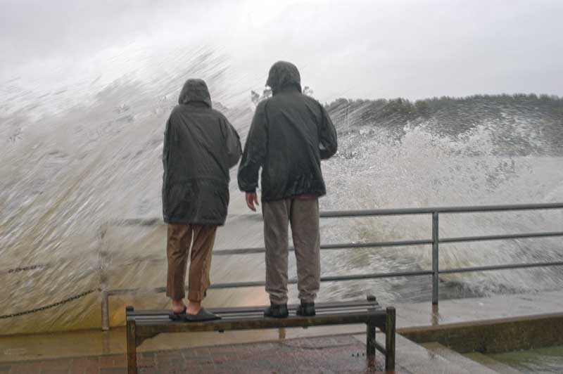
But what happened next, in the early hours of Friday September 19, was extraordinary. The Bay began to rise, and it kept rising. Even as the clouds pulled away and the wind began to lie down, the water kept rising.
On the Chesapeake Bay, typical wind driven flooding and surge events move the top layer of water and are, therefore, somewhat limited in scale. However, Isabel’s westerly track brought to the Bay strong easterly and then southerly winds and an uncanny sense of timing. The combined circumstances “de-stratified” the Bay’s water column and pushed the entire water column northward.
We now know all of this because a year later, in November 2004, a scientific conference was convened in Linthicum MD, to address the forecasts, impacts, and responses to Hurricane Isabel as it interacted with the Chesapeake watershed. All of the papers presented and panel discussion summaries are available at chesapeake.org/pubs/Isabel/isabel.htm. The body of work is fascinating; it is largely focused on the Friday morning that the water that kept rising, rising, rising.
Isabel’s westerly track and resulting high waters were remarkably similar to that famous 1933 storm. And Isabel’s wedge of water pushed the Bay to extreme heights, approaching and surpassing the 1933 marks. Gauges at the mouth of the Bay Bridge-Tunnel reported 7.12 feet above mean high water. Across from Hampton, Sewell’s Point recorded 7.53 feet.
Moving north, where the incoming water was trapped, with minimal outlets, the stats were similar and amazing. 7.5 feet above mean high water in Washington, DC, 7.47 at Tolchester Beach, and 8.34 in Baltimore. A couple hundred low-lying homes and other structures were severely damaged, eventually forcing more than 200 Maryland families into FEMA trailers
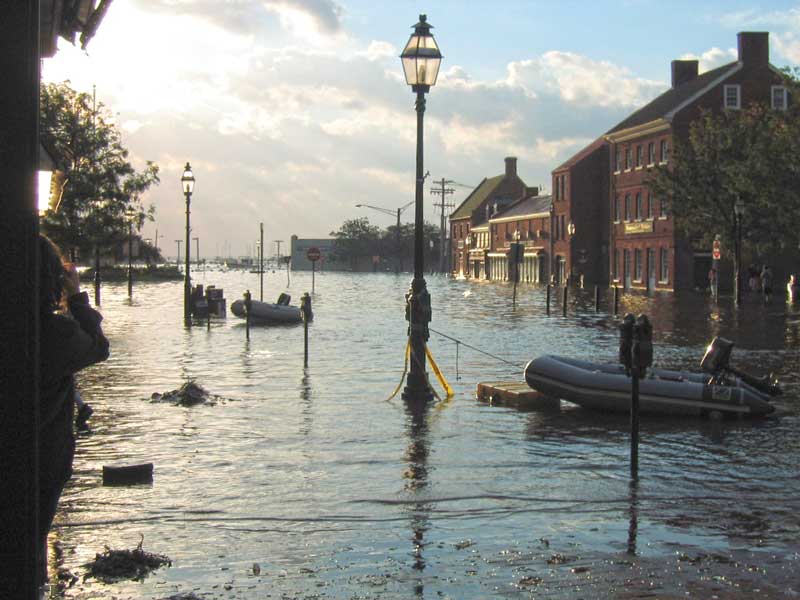
In Annapolis, the waters peaked just over eight feet above mean high water and a few old-timers who recalled the old storms emerged and declared this water to be the highest they have ever seen in the ancient city. A crowd gathered at the foot of Main Street and along the higher, narrow streets leading down to Compromise Street and, as often happens in sailing towns, a sort of party atmosphere developed; although it was still early in the morning. Predictably a couple of folks dragged out kayaks and floated them over parking lots. A brave soul ran a RIB, under outboard power, along Compromise Street then across, to Dock Street where he navigated around the exposed tops of parking meters. A handul of kids were permitted to swim in the oily water over sidewalks and parking spots (in the process, dozens of ear infections were doubtlessly spawned). Thousands of photos were snapped. A legend was born.
The high-water mark was made around 8 a.m. and then, just as suddenly as it rose, the waters turned and began to run out the Bay. I left the City Dock circus scene and hustled back to Eastport where I boarded a small powerboat and headed out under a warming sun. Even at the mouth of Back Creek, famously blown open for navigation in that 1933 storm, swirls of moving water provided visible clues into what was happening below the surface. As I motored past the old McNasby Oyster Packing plant I saw a gathering crowd. The 1918 structure was among the more heavily damaged structures and large chunks of its walls had fallen into the creek. The building has since been beautifully restored and continues to serve as the home of the Annapolis Maritime Museum.
The Empty Space Left Behind
In the wake of these big storms, there can be an odd vacuum effect and that morning it felt strong out on the Bay. On the water, it was as if all the atmosphere’s energy had been pulled away by the storm, leaving behind a windless, cloudless silence, air scrubbed bright and clean.
The energy that remained was below the boat, in the water itself. In the center of the Bay, at the Red # 2 east of Tolly Point, the current was ripping and I cut the engine. Free of the shoreline and the gawking crowd, the air smelled of tangy salt. The water ran deep blue and cold, it smelled and tasted of the open ocean. This was unlike any Bay water I have seen before or since. The water was forcefully pushed here, 140 miles north from the Atlantic, trapped momentarily, and was now rushing back to restore equilibrium.
Nature self-regulates. Nature balances. In this case, the process took place silently but aggressively, draining the incursion out toward the deeper ocean and pulling my little boat south along with, it in a swirl of cold, salty blue water.
By the next day, the salt water was gone and a new stream of fresh water entered the main stem of the Bay, rainwater runoff from the Susquehanna and other upstream feeders.
In Isabel’s Wake
As the waters receded shoreside damage was revealed to countless docks, basements, and other properties. The Naval Academy, boats secured and accounted for this time around, suffered major damage to its shoreside facilities. Much of the Academy was built on landfill, and many of its classrooms and laboratories are at and even below sea level. More than 120,000 square feet of space was impacted, half of the Academy classroom space was rendered unusable, and tens of millions of dollars of damage was reported. Among the damaged facilities was the Academy’s famed 382-foot-long, 16-foot deep model towing tank.
The repair and recovery work at the Academy took place out of the public eye. But outside the Academy gates, the community camaraderie and spirit was very strong and very evident. With so much warning and proper prior planning the boat damage was minimal. The cheery crew at Fawcetts reopened for business as the floor mopping was still underway. All along the waterfront neighbors and slipmates pitched into recovery efforts.
Unforgivably, along the Academy seawall a pair of privately owned vessels were wrecked and sunk in a manner remarkably similar to Vamarie scene 49 years earlier. Ahead of the forecast strong easterly winds, a foolish owner had anchored both of his sailboats just to weather of the Academy rocks. Both broke loose and emerged from the event smashed and underwater.
The New Normal
Thanks to the openness of the scientific community, we now understand some of Isabel’s impacts on the Bay’s ecosystem. Fisheries scientists who trawled the Bay before and after the storm reported at the Linthicum conference that “Species richness increased” in the immediate wake of Isabel. In the northern Bay were “previously uncommon freshwater fish that possibly were transported to the Bay’s main stem by the high freshwater flow from the Susquehanna River.”
To the south was a massive increase in the number of adult Bay anchovy that either moved into the Bay from the ocean because of the storm or were pushed out into the Bay from upstream tributaries by run-off. Remarkably, the days after Isabel saw a superabundance of Atlantic Croaker in the southern Bay, more than 30 times the previous decade’s average. The scientists suggest that the Croaker was pushed by the storm into the Bay from their coastal ocean spawning sites.
The fresh water visitors and the Croaker were but near-term outliers and they too soon returned to natural balance. The storm seemed to produce no negative effects on the fish populations or other parts of the Bay’s ecosystem. Shoreside, there was clean up and lasting property damage to deal with, it would be over a year before the larger of the abandoned sailboats on the Academy seawall, a Columbia 43, was expensively removed by more than a dozen Navy divers. And a year after the storm, more than 150 Maryland families were still living in FEMA trailers as a result of damage to their homes.
Aside from these sad examples, the Bay, its ecosystems, and its residents reestablished order quite quickly. In fact, a few days later, everything seemed back to normal and the summer quietly and beautifully gave way to autumn.
Twenty years have passed. There have been storms and there has been flooding, but the extraordinary set of circumstances that conspired to swell the Bay in the wake of Isabel have yet to be repeated and may never be. New storms and new floods are over the horizon, heading our way, no doubt. In the coming years, we will wait for these events, we will prepare for them, and we will live through them. At the same time, we slowly but steadily turn into the old-timers and one day we will be the ones who step out into the bright post-storm sunlight, squint at the water levels, and proclaim, with great certainty, "It sure is high today but it's nothing close to what we saw with Isabel.”
David Gendell is the founding editor of SpinSheet and the author of "Thomas Point Shoal Lighthouse: A Chesapeake Bay Icon."


