See the Bay: James River Then and Now
For at least several millennia, tidal rivers such as the James have provided humans with natural infrastructure. To the Chesapeake’s Native people, who had neither wheels, draft animals, nor bridges, rivers connected—not separated—the land on their opposite sides. The same went for connecting main river shores, by canoe, to nearby creeks, marshes, and swamps that were especially valuable for foraging, hunting, and trapping.
Captain John Smith’s historic map of 1612, the first accurate cartographic depiction of the Chesapeake, shows how clearly Native people oriented their towns and villages to the Chesapeake’s big tidal rivers. The English followed the pattern in the 17th and 18th centuries, trading directly from farm wharves and colonial towns with England and the Caribbean. Steamboats, working sloops, and powerful schooners sustained regional trade in the 19th and even into the first half of the 20th century.
Today, despite modern highways, community ties to navigable waterways survive. Here’s an example: Virginia’s Historic Triangle, composed of Jamestown, Yorktown, and Williamsburg, and readily accessible from Interstate Highway 64, is a well-known, magnetic destination for visitors. Nevertheless, there’s a classic river community hiding in plain sight directly across the James River from Jamestown. Even better, there’s no bridge to cross.
Visitors ride a state-operated ferry, at no cost even if their vehicle is towing an outboard skiff or has a canoe, kayaks, or paddleboards strapped to the roof. The ferry would be one of the four vessels in the Virginia Department of Transportation’s Scotland-Jamestown Fleet: Pocahontas, Powhatan, Surry, and Williamsburg. The ferries dock on the south bank at Scotland Wharf in Surry County, as predecessor ferries have since 1660. To get close to what made this country so valuable to both the Native Americans and the English, it’s important to get on the water in a small boat, the way the Native people (the Paspahegh) and the Jamestown settlers did.
A Two-Day Trip on a Small Boat
You can do so on both sides of the James, making for a perfect two-day trip with a comfortable, small hotel in the middle. On the Jamestown Island side, spend a day exploring the Powhatan Creek Park and Blueway, which drains land between Williamsburg and Jamestown, entering the James behind the Island. Cross the big river on the ferry to spend the night and discover (Capt. Smith’s synonym for explore) Gray’s Creek in Surry the next day.
For Powhatan Creek, reserve kayaks, paddleboards, or canoes ahead of time from the James City County Marina, which lies at the base of the Island. (If you have time, you can also rent bicycles to pedal the loop around the island and visit the exhibitions at the National Park Service’s Visitor Center and Historic Jamestowne, which will give you a broad perspective on how the land and water lie together.)
You can explore Powhatan Creek by paddling out and back from the marina, but if you can set up a shuttle, launch at the Park/Blueway’s access point just off Jamestown Road and paddle down to the marina (about six meandering miles). You might find it useful to check NOAA’s Current Table for Jamestown Island and plan your trip to have a fair current. Just downstream of the Jamestown Road Bridge, you’ll come upon a huge bald cypress that foresters have dated to the beginning of the 17th century, which means it was a sapling when the Jamestown settlers arrived. It’s old, weather-beaten, and hollow, but stop by it briefly and think about all it has seen in its years.
Make sure you’re back at the marina in time to catch an afternoon ferry. On the 15-minute, three-mile crossing, the ferry offers miles-long views up- and down-river, basically what the first English colonists saw in 1607 when they chose to settle at Jamestown.
From the Scotland Wharf ferry terminal, drive a mile-and-a-half south on Route 31 and turn right onto Marina Drive. At the end, you’ll find Gray’s Creek, a tidal gem with state Scenic River status.
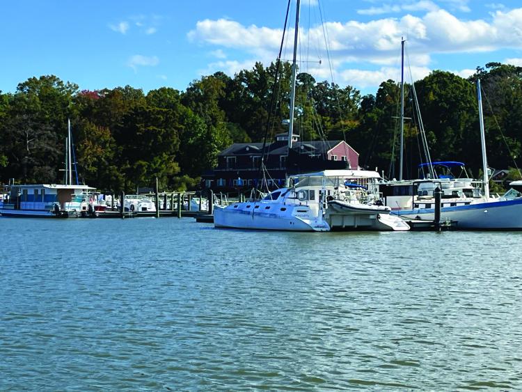
Today, Gray’s Creek Landing offers a free, two-lane launch ramp. Hard by it lies the Surry Seafood Company’s Restaurant, Hotel, and Marina, a country seafood restaurant with four hotel rooms on the second floor and 45 boat slips on floating docks just inside the mouth of the creek. Surry Seafood makes a great base of operations, even if you haven’t brought your own boat(s). The Surry County Parks and Recreation Department offers kayak rentals and tours here in the summer and fall (call to check if they will be open when you visit).
On both Powhatan and Gray’s Creeks, prior to 1607, Native people would have found the waters rich in spring with yellow (ring) perch, white (stiffback/gray) perch, river herring (alewives and bluebacks), and hickory shad. The main river would have swelled with American shad, striped bass (rockfish), and Atlantic sturgeon. Now the creeks also hold largemouth bass, black crappie, and blue catfish.
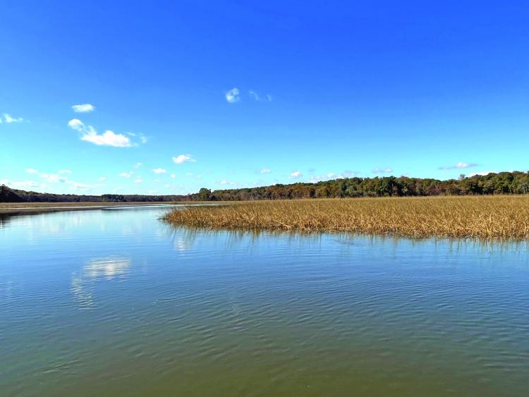
Both creeks emerge as fresh water from sprawling forested wetlands, Long Hill Swamp for Powhatan and Dark Swamp for Gray’s. The wooded margins form effective filters, valuable for ensuring good water quality downstream. As they meet sea level, their riparian forest buffers turn to riverine tidal fresh marsh. Rimmed by bald cypress trees, the creek channels each flow six miles to the James, though as the osprey flies, the distances point-to-point are more like three miles.
For the Native people who lived here before the English came, the firm land on the outsides of the creeks’ deep meander turns made natural sites for villages, crop fields, and woods for hunting game like deer and turkeys. The marshes on the inside turns offered edible plants such as wild rice, narrowleaf cattails, and tuckahoe for foraging, plus waterfowl and furbearers for trapping.
Freshwater springs flowed from the creek’s headwaters and high banks. Near their mouth, the creeks turn brackish as tides from the James leave their traces. Powhatan, located within suburban communities around Williamsburg, has more houses along its banks, plus National Parkland. Gray’s comes by its Scenic River designation honestly, with wide buffers along its forested shorelines and numerous side branches to explore.
Discovering Gray’s Creek
On a visit to Gray’s Creek last fall, a friend and I explored all the way up to the head of tide in my 17-foot outboard skiff; the marsh guts and side creeks make Gray’s a natural for exploring by canoe, kayak, or paddleboard. On our visit, the marshes were turning brown, and the color was in the trees: red, orange, and purple in the maples, oaks, and gums, with russet heather in the cypresses. Soon, windy cold fronts would bring migratory birds to feed on the marshes’ bumper crop of seeds and grain, with many waterfowl staying for the winter because of them. We saw several resident bald eagles and great blue herons.
Colonial history around Powhatan Creek is well-known, but remember that the James connected the English settlement closely with Gray’s Creek. In the summer of 1609, Capt. John Smith ordered the building of a defensive fortification called the “New Fort” (marked on his 1612 map) to guard against attacks from Natives and Spanish. He planted a Maltese cross in the wooded swamp at the headwaters (which makes Gray’s part of the Captain John Smith Chesapeake National Historic Trail). The fort was never completed, but its earthworks remain visible high on the eastern bank.
Five years later, Chief Powhatan included this land in the dowry for his daughter Pocahontas’s marriage to John Rolfe. The waterway was first named Smith’s Fort Creek and later Rolfe’s Creek. On March 22, 1622, hostile Natives throughout the colony rose up in coordinated rebellion against the English. One warned an Englishman who lived on the creek, Richard Pace, of the plan. The ambush killed more than 300 colonists along the James, but Pace crossed the river just in time to alert Jamestown, saving many English lives.
Today, Gray’s Creek still looks largely the way it has for centuries, inviting exploration, birding, fishing, and just plain drifting and reflection on what the Chesapeake’s waterways have meant to the origins of our country. Take a long weekend and go see for yourself.
By John Page Williams
Find more Chesapeake destinations.


