Exploring the Head of the Chesapeake Bay with Captain John Smith
When the Virginia Company of London sent the first colonists to Virginia in December 1606, one major objective was to see if the “Great Bay of Chesapeake” was actually the approach to the fabled Northwest Passage to the Orient, which they were sure existed. That quest lay at the heart of Captain John Smith’s explorations to the head of the Chesapeake in the summer of 1608, along with meeting the Native tribes along it.
In the process, he mapped the waterway with amazing accuracy, firmly establishing the link between the Susquehanna River and the Chesapeake Bay. When the rapids that he named Smith’s Falls (just above today’s Port Deposit, MD) stopped the Discovery Barge, he established finally that the Northwest Passage did not exist in the Chesapeake.
The Susquehanna is, however, no mean river. The longest river on the East Coast of the United States, it supplies about half of the freshwater flowing to the Chesapeake. Flowing south some 440 miles from Otsego Lake in Cooperstown, NY, to reach sea level at Smith’s Falls, it gathers rainwater from large tributaries like its 228-mile-long West Branch and the 104-mile Juniata, as well as many smaller creeks and streams. The big river is tidal for about five miles from the falls down to the opposite ports at its mouth, Havre de Grace and Perryville. Beyond there, it opens out into the six-mile-wide Susquehanna Flats and the Upper Chesapeake.
Ironically, Smith caused confusion that persists today by drawing a distinction between the Susquehanna and the Chesapeake. In reality, they are two sides of the same coin. The Chesapeake’s main stem is actually the Susquehanna’s tidal basin. Efforts to restore the health of the Chesapeake would be much easier today if people in Pennsylvania, Maryland, and Virginia saw the river and the Bay as one whole.
Captain John Smith at the Head of the Bay
On the voyage to the Head of the Bay in the summer of 1608, Smith and his crew caught fair wind and current from the James, covering the 200 miles to the mouth of the Susquehanna in four days. That is good time indeed for a 30-foot, heavily laden working vessel of early 17th-century shape, construction, and sail plan. Smith may have received his captain’s commission on a battlefield, but he had become a skillful small boat sailor, too. After turning around at Smith’s Falls, the English traveled back downriver and around to the east, visiting Furnace Bay and carefully mapping both the North East River and the west side of Elk Neck.
As they rounded Turkey Point, they met a war party of Massawomeck warriors who had just raided the King’s Village of the Tockwogh in the Sassafras River. Each group regarded the other cautiously, but they talked (in sign) and traded. The next morning, the English sailed up the Sassafras to the Tockwogh village. Those people, still smarting from the previous day’s raid, were at first suspicious of the English, but seeing Massawomeck shields and spears on the Discovery Barge (gained by trading), the Tockwogh concluded that the English had fought and beaten their enemies and hailed them as heroes. Smith cannily did not disabuse them of that notion.
Finding one Tockwogh warrior who could speak the Powhatan language, Smith inquired about the Susquehannock (about whom he had learned from a lower Bay chief) and asked the interpreter to go upriver to invite the Susquehannock chiefs to come down and talk. Smith and crew took the Tockwogh across the Flats to the big river’s mouth and set him ashore at the long path upriver. While he made his way to the Susquehannock town (today’s Wrightsville, PA), the English crossed the Flats again to explore the Elk River...
Several days later, they met the Susquehannock chiefs in the river’s mouth, probably on Garrett Island. After some conversation and trading, five of the Susquehannock chiefs asked to cross the Flats aboard the Discovery Barge. They did so, arriving for a feast at the Tockwogh village. The next day, Smith and crew left the village, refusing entreaties to stay and protect the people from the Massawomeck. Smith promised to return the next year, though he never did.
The English sailed the Discovery Barge across the Bay into today’s Bush River, explored the Gunpowder and Bird Rivers, crossed the mouth of Middle River, and returned to the Eastern Shore, spending the night on today’s Swan Creek by the Town of Rock Hall. The following day, they left the Upper Bay, sailing south to the mouth of the Patuxent River.
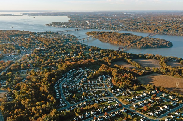
Exploring the head of the Bay today
Today, the Head of the Bay shows how successfully Captain John Smith’s map drew people from the Old World to the New World. This region is rural bordering on suburban, the result of being almost equidistant from Baltimore, Wilmington, and Philadelphia. It’s the home of the “Pennsylvania Navy,” boaters who birth their vessels here, tow them to area launch ramps, or hunt up soft landings for canoes and kayaks.
Cruising sailboats regularly make the trip up the Chesapeake, into the Elk River, and through the C&D Canal to Delaware Bay. If they linger, they tend to do so at the marinas in the Sassafras. There is a lot more to see, but doing so requires careful attention to narrow channels (especially around the Susquehanna Flats), research about Smith’s travels here, and some imagination. The latter involves thinking hard about what it was like sailing and rowing a 30-foot open boat when this area was wilderness and about how the Tockwogh and Susquehannock lived; how they chose the sites for their villages; how they fished, farmed, foraged wild plants, and hunted; how they made and traded for their tools; and with whom they built alliances.
Take that point of view and travel around the Susquehanna Flats, learning what you can by visiting Havre de Grace, Port Deposit, Perryville, North East, and the Sassafras. If you go to Havre de Grace, plan to visit the Havre de Grace Maritime Museum. It offers an exhibit that invites you to “Step back in time, discover life in the Upper Bay 400 years ago and go Beyond Jamestown. You may be surprised at what you discover.”
Don’t miss this short trip
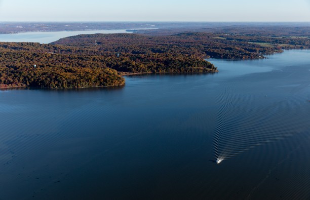
The one “don’t miss” short trip in this part of the Susquehanna/Chesapeake system is a 2.6-nautical-mile circumnavigation of Garrett Island, under sail, power, or paddle. Don’t worry about the two bridges crossing the river over the island: air draft for both is more than 80 feet. Note also the narrow channel’s depths on the east side of the island, which drop to more than 65 feet. It takes a lot of volume to carry all that water coming from Otsego Lake and everywhere else below it.
Pay particular attention to the view upriver from the northern end of the island and the view downriver from the south end. The former looks to—and looks like—the Susquehanna River in Pennsylvania. The latter looks to—and looks like—the open Chesapeake. Go slowly and soak in the scenery.
Garrett Island forms a striking transition point from huge, free-flowing river to estuary. It’s understandable that Capt. Smith changed the river’s name there. I guess he couldn’t open Google Earth that day, but you can, before your visit. It’s extraordinary.
To learn more about the Captain John Smith Chesapeake National Historic Trail, visit A Boater's Guide to the Captain John Smith Chesapeake National Historic Trail , or nps.gov/cajo.
By John Page Williams
Find more Chesapeake destinations here.


