Sailors, Campers, and Environmentalists Explore the Rhode River on the Chesapeake
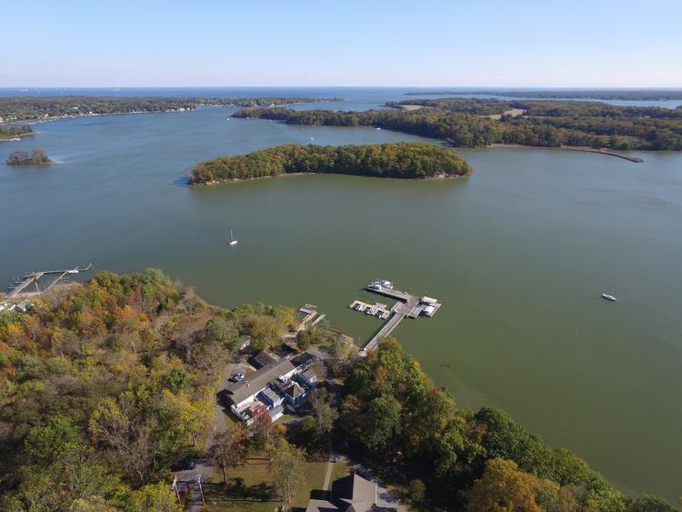
The Rhode River anchorage “between the islands” is one of the best kept secrets of Chesapeake Bay cruisers. Here, in shallow but forgiving water you can drop the hook and spend a delightful evening listening to the placid sounds of the night… unless you happen to be anchored too close to the 116-year-old YMCA Camp Letts. Then, you’ll be transported back to your youth as campers call out to one another with a cacophony of screeches worthy of generations of campers who have plied the tepid waters of the Rhode at this very spot.
60 years ago, a dairy farm
Less visible from the water is one of the jewels of the Smithsonian portfolio: the 2650-acre Smithsonian Environmental Research Center (SERC). Here, scientists quietly investigate and report on the delicate interaction between the land and the water in coastal ecosystems like those encountered within the shoreline of the Smithsonian’s 15 miles of protected shoreline.
The center got its start in 1965, after the Smithsonian received an abandoned, 368-acre dairy farm in a surprise bequest. “At first, the board of regents didn’t know what to do with it,” said media relations coordinator Kristen Goodhue. “There was even talk of selling the property, but fortunately the Smithsonian Secretary at the time—Dillon Ripley—stepped in and saved it. He thought it would be a perfect spot for researching delicate coastal ecosystems, where the land meets the sea.”
The research center is ground zero for environmentalists: trouble here spells trouble 50 miles out. If the grass shrimp were to die out, the ripple effect on the crab and fish populations of the Bay would be felt in restaurants all along the East Coast.
The facility includes 110 full-time employees doing research, education, and administration work (technicians, researchers, and support staff). Another 50 are employed in maintenance and security. Permanent employees are supplemented by 40-plus paid interns and PhD candidates who come from all over the world to participate in Smithsonian research projects.
Goodhue explains that the Smithsonian’s areas of study include biodiversity and conservation, biological invasions, ecosystems ecology, environmental pollution, food web, global changes, history and archaeology, parasite and disease ecology, watershed, and land use.
Research at SERC focuses on the coastal zone. Nearly 70 percent of the world’s people live in a coastal zone. Coasts are some of the most diverse, life-giving ecosystems on Earth, but they’re also under intense pressure from climate change, invasive species, and other major environmental impacts.
The center provides science-based knowledge to meet critical environmental challenges. It serves as a natural laboratory for long-term and cutting-edge ecological research, exploring the most pressing issues affecting the environment, including toxic chemicals, water quality, invasive species, land use, fisheries, and global change. SERC also explains environmental science in innovative ways that change how people view the biosphere and inspire them to take an active role in sustainable stewardship of the Earth.
Scientists who get their feet wet
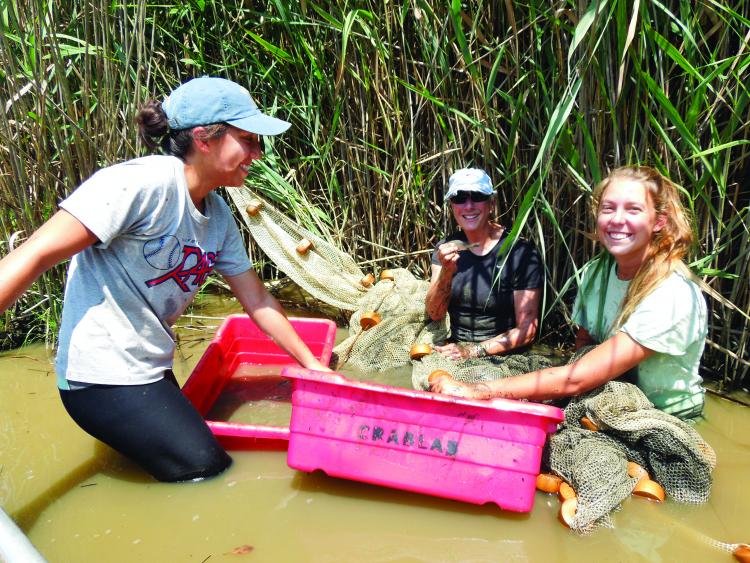
The scientists who work at SERC are not ivory-tower academics. "Ecology is a messy science, and our scientists are used to working in the mud!" says Goodhue.
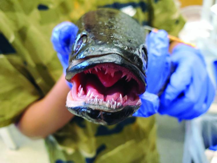
They're also no strangers to the 'ick' factor. For example, she added, in one lab scientists may be measuring parasites in tiny grass shrimp, and in the lab next door there could be somebody dissecting a snakehead to find out what this invasive creature had for lunch. (For the record, the later is a smelly, slimy operation. Stomach contents are often sent away for DNA testing to confirm the identify of the goo.)
Summer is a busy time at SERC. At any given time, there are hundreds of significant projects on the drawing board, in the process of examination, or in the final stages of reporting. Scientists have access to 18 labs on-site. Many projects are initiated at the center and carried out in the field. The scope of work includes work all over the Chesapeake Bay, in Florida, and even Alaska.
Goodhue points with pride to several programs that are delivering breakthrough results while engaging the local community of citizen scientists. “For example,” she says, "our Nearshore Seining team tracks fish and shrimp in the Rhode River by dragging large seining nets to shore and seeing what they catch. Our Fisheries Conservation Lab does similar surveys using both seining nets and trawling. Our Coastal Disease Ecology Lab looks at parasites that infect Rhode River animals, like oysters, clams, and shrimp. And our education team teaches students about Rhode River life by letting them catch fish in large nets at our seining beach.”
Engaging citizen scientists
One of the newest areas of investigation is a joint project in conjunction with NASA. Here, the Smithsonian is recruiting watermen, boaters, and the general public to help it validate a spy-in-the-sky satellite water quality tracking program.
“At least four satellites pass over the Bay in the course of two days,” says Dr. Alison Cawood, director of public engagement. “The quality of the digital images these satellites take is amazing… down to one square kilometer. What we are asking our citizen scientists to do, with the aid of cell phone app, is to take pictures within a simple protocol of the water in various locations. Then, we can compare the turbidity results from this on-the-scene data gathering with the results from the 500-mile-high satellites. Hopefully, we will be able to correlate what the satellite sees with what is happening on the water. Just think of the time that will save… and it will help us get real time data faster... for better, more informed decisions.”
The Water Watch Program is in the initial stages of rollout. Presently, fewer than 50 citizen scientists have been through the training. “We are looking to expand our network over the next several months,” says Dr. Cawood. “People who want to help out can go to our website and get more information or sign up for either an in-person or virtual training session.”
South River sailor and environmentalist Chris Graae has been testing the Hydro Color App for the past two months. He took the two-hour introductory course at SERC and has been sending in data every week from his dock on the South River.
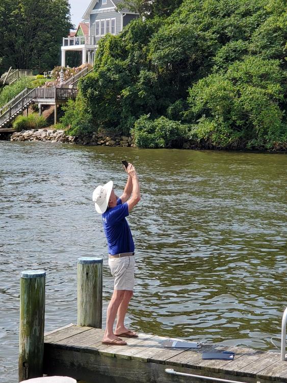
I watched Graae conduct his testing. Not very complicated. The app on his phone is programmed to uplink coordinates and data collected. First, Graae took a photo of the grey card with the sun at his back. Then, he took a reading of the sky. He took a reading of the water. He uploaded the information and received a confirmation email with a synopsis of the data. Graae repeated the process three times. From start to finish, the testing took five minutes.
Graae thinks the program can only get better as it rolls out with more participants. “The program uses a very sophisticated app, which is user-friendly but not mindless, so there is a little thinking going on. It knows your longitude and latitude and is somehow set up to signal you when you have positioned the phone camera oriented correctly in the two axes with a green highlighted ‘go’ window to take the shot in the right spot for the card, the sky and then the water. It would be great to have a network of sailors all over the Bay participating in the program. The more data, the better.”
The day I watched Graae take his readings was shortly after a torrential rain. “My readings showed three to four times the turbidity as the week before. I guess this thing works!” said Graae.
SERC gets crabby
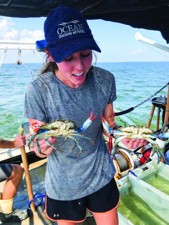
SERC has been leading the way in another area of research that is central to understanding the current reduction in Chesapeake Bay blue crab numbers: blue crab reproduction.
“There are a lot of factors intrinsic in what we now see as a significant decline in our blue crab population,” SERC senior scientist Dr. Matt Ogburn told SpinSheet. “Runoff, loss of sea grass habitat, and predators all contribute. At SERC we have been focused on the reproduction cycle of our Bay crab population. We have found that early in the reproductive cycle of the females there are often fewer males available to mate than might be the case later in the year. Those males are busy mating, but because of their increased activity, they are unable to replenish their sperm to the amount required to deliver a level of sperm to the female that is meant to last two to three years.”
Ogburn says that Year One female fertilization is often sufficient, but, “if the female continues to produce eggs in years two and three, there may not be enough sperm to fertilize all of her eggs. We think that can result in an overall net reduction of fertilized eggs of five to 10 percent.”
I joked with Matt about the viability of the male blue crab’s sperm due to the crustacean’s overactive sex life early in the year. Though Ogburn quickly pointed out that for the blue crabs, it's no laughing matter. Male blue crabs need time to replenish their sperm, he explained. While they're not infertile if they mate indiscriminately, they're not breeding to their full potential either.
Visit by land or water
You may access SERC via land or water. The turnoff to the facility from Edgewater’s Muddy Creek Road is well marked. Boaters can dock non-motorized dinghies, kayaks, and standup paddleboards at the floating dock located just east of the Reed Center Wet Lab Research docks.
The ground floor of the Reed Education Center is open to the public. Here you will encounter an introduction to SERC and some examples of the coastal ecosystem.
The Charles McC Mathias Laboratory, inland from the public docking area, is not open to the public. This imposing $56 million 92,000 square foot laboratory is the only LEED Platinum building in the Smithsonian’s physical plant portfolio. (LEED ratings range from bronze to platinum and are awarded on the energy efficiency and ecological footprint exhibited by the structure.)
The lab is stunningly beautiful as it rises from a natural wetland with buttresses of glass and steel. It features on-site solar energy production, geothermal heating and cooling, water reclamation system, and stormwater management wetlands. The architect for the building was Ewing Cole; the exterior landscape designer was Poole Design LLC, and the general contractor was Hensel Phelps. The structure was completed in 2014.
A recently renovated 18th century home, the Woodlawn House, located near the center’s entrance gates gives a visitor a glimpse of what life was like on the river from Colonial times until the early 1900s. You could walk to the Woodlawn house from the docks, but it would be a hike. Better to off load a bike and make the trip under pedal power.
No doubt about it. A visit to SERC will leave you scratching your head wondering why in the world you haven’t made a stop there before while enjoying one of your favorite Rhode River cruising anchorages.
By Craig Ligibel


