Info for Boaters About Downdrafts in Thunderstorms
Wind from a thunderstorm – called a downdraft—can easily exceed 70 knots. This is a significant hazard for boaters, and understanding downdraft formation is essential while boating. All mature thunderstorms also have an updraft, and understanding downdrafts begins with an explanation of updrafts.
 Updrafts provide the storm with its energy – air that is relatively warmer and moister than its surroundings. Rising air within an updraft steadily cools, and eventually the water vapor condenses into small cloud droplets. Over time, these cloud droplets merge into raindrops (it takes a million cloud droplets to make a raindrop). If the updraft rises high enough, many of the raindrops freeze into ice crystals and hailstones. As the storm matures, some of these raindrops and hailstones are ejected from the updraft and fall toward the ground.
As raindrops and hailstones fall, they create a descending column of air known as a downdraft. Dry air entering the downdraft causes some of the raindrops and hail to evaporate before reaching the ground. Evaporation further cools the air in the downdraft, increasing the speed at which it falls.
After reaching the ground, the downdraft races away from the storm. The direction and speed of a downdraft is unpredictable. It may radiate away from the storm in all directions or may follow a narrow channel in a particular direction. The leading edge of a downdraft is known as a gust front or outflow boundary.
Weather technology can help assess an approaching storm for risk of a downdraft. Some weather radar apps allow recent observations (Local Storm Reports, or LSRs) of strong winds, tornadoes, or large hail to be overlaid on the latest radar image. LSR’s aren’t perfect, and they can’t predict the rapid strengthening of a downdraft, but they do provide valuable insight on a storm’s recent behavior.
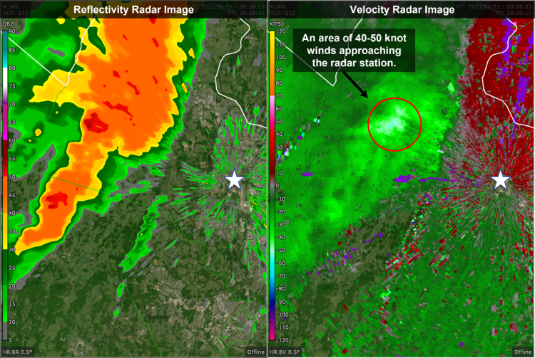
Another less well-known weather radar product – velocity imagery – can provide clues about an approaching storm’s wind field. Using the Doppler Effect, velocity imagery shows the motion of rain and hailstones relative to the radar station. The right panel on the radar image below suggests a 40 to 50 knot downburst is moving east toward the station (represented by the white star). Learn about interpreting velocity radar imagery here.
~By Mark Thornton of LakeErieWX
Learn much more about forecasting thunderstorms at our three-part webinar in March.


