How Has the Chesapeake Changed from John Smith’s 1608 Bay?
NOAA’s Chesapeake Bay Interpretive Buoy System, consisting of yellow buoys that provide weather and water-quality data for boaters up and down the Bay, also shares Chesapeake history along the Captain John Smith Chesapeake National Historic Trail (accessible by buoybay.noaa.gov, (877) BUOY-BAY, or app). Last time we explored Captain John’s Smith’s Chesapeake “then and now” on the Northern Bay. Here’s the southern version:
1608: On July 17, Captain John Smith and his group of explorers ran aground at the mouth of the Rappahannock River. While they waited for the tide to come up, Smith speared a ray while fishing. The ray stung Smith in the wrist, and Smith’s arm, shoulder, and chest swelled from the ray’s toxin. Fearing death, Smith discussed funeral plans with his group. A doctor with the group assisted, and by evening, Smith was well enough to eat the ray for dinner. The location has been called Stingray Point ever since.
Scientists estimate that when Smith visited the area, sea level was about four feet lower than it is today. It is highly likely that in 1608 the shoals around the point were growing a dense mixture of the Chesapeake’s two high salinity underwater bay grasses, eel grass, and widgeon grass, which attracted the fish that the captain, as he said, “sported” himself by spearing with his sword. In July they could well have been a mixture of Norfolk spot, Atlantic croakers, speckled trout, rockfish, sheepshead, and flounder, as well of course, as the infamous stingray. That was probably a southern stingray judging by the captains’ description of its having its spine set on the middest part of its tail. Unlike the cow nose rays more common today, whose spines lie at the base of their tails.
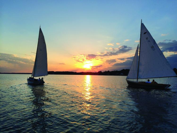
Today: Sailors passing Stingray Point are either headed into the 194-mile-long Rappahannock River or into the 24-mile-long Piankatank to the south of it. Up the “Rap,” cruisers have many options: fine dining and docking at the Tides Inn in Irvington, quiet and well-protected anchorages up the Corrotoman River, a stroll in the quaint town of Urbanna, or docking at a marina to find marine services in Deltaville. If you cruise into the mouth of Carter Creek on a Wednesday evening in summer, you may have to steer clear of Cape Dory Typhoons racing with the Rappahannock River Yacht Club.
Sailors who wish to find quiet will find it on the Piankatank, where you can tuck into several protected creeks and anchorages, including Fishing Bay, home of the Fishing Bay Yacht Club, where racing sailors of all ages enjoy an active weekend regatta scene.
1608: Captain John Smith was a frequent visitor to this part of the Bay; he passed the current-day site of NOAA’s York Spit CBIBS buoy at least nine times during his stay in Virginia: four times on his two round trip voyages of exploration up and back down the Chesapeake’s main stem in the summer of 1608, and five more times on his round trips to Powhatan’s capital of Werowocomoco, about 20 miles up the river, in the winters of 1608 and 1609.
In February after his return to Jamestown, Smith made his first trip by water—in frigid weather—taking Capt. Christopher Newport to meet Powhatan. That voyage also included a run up the Pamunkey so that Newport could meet Powhatan’s powerful brother, Opechancanough, who had been Smith’s captor.
At the end of Smith’s second exploratory voyage up the Bay in early September, he and his crew passed here and anchored for the night in the mouth of the Poquoson River, which they had named Gosnold’s Bay. That evening, however, a thunderstorm sprang up. They raised sail and ran before the strong wind, navigating by what they could see during lightning flashes until they rounded Old Point Comfort and the squall blew over.
In October of that year Smith sailed again to Werowocomoco under orders from Capt. Newport with gifts for Powhatan, but he returned to Jamestown overland that time. At the end of December he sailed again to Werowocomoco to trade for corn. It turned out to be his last, and most hostile, encounter with the great chief. He also traveled up the Pamunkey to trade with Opechancanough, another encounter that ended badly, and up the Mattaponi. Busy though he was with diplomacy and defense, he apparently took enough notes on this trip to map both tributaries with remarkable accuracy. He returned to Jamestown in mid-February, passing this buoy site for the last time.
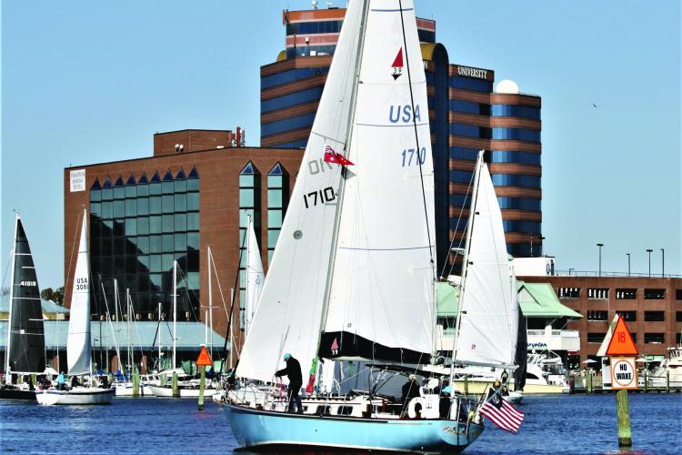
Today: You don’t have to travel nearly as far upriver as Captain John Smith to find friendly locals, as the York River Yacht Club is located in Gloucester Point, VA, across the river from Yorktown. Members enjoy racing on Wednesday nights and frostbite racing in winter, cruising together up and down the Bay, and socializing.
Cruisers who sail farther north of York Spit head into Mobjack Bay with its myriad options for protected anchorages in four rivers: Severn, Ware, North, and East.
1607: After an exploratory trip up the river in early May, 1607 to look for suitable sites, the English colonists chose Jamestown Island because it lies far enough up the James that their presence would not be obvious to a Spanish ship entering the mouth of the Chesapeake, and there was no native village there. In addition, the narrow neck of marsh connecting the island to the mainland made it easy to defend from native attack. Finally, the river’s channel swung close enough to the island that they could moor their ships at the bank. On May 13, they landed there, claimed the land for England, named it for their King, James I, and began to create a settlement, including a fort.
From the native perspective, the island lay within the hunting territory of the Paspahegh, a tribe under allegiance to the region’s paramount chief, Powhatan, whose name the natives had long since given to the river (and the name by which some of their modern descendants still refer to it). The Paspahegh were not pleased by the settlement and attacked it a short time later, while the colony’s leaders (including Captain John Smith) were away exploring the James up to its fall line. The fort’s palisades were still incomplete, and while the English were able to repulse the attack, the Paspahegh succeeded in wounding several colonists and killing a boy. When the leaders returned, they turned everyone to finishing the palisade.
The colony’s relations with the Paspahegh eventually improved from overt hostility but remained fragile for obvious reasons. In the fall of 1607, for example, Smith had much more success trading for corn at the villages of the Chickahominy, who were independent from Powhatan, than at with the Paspahegh. The primary practical challenges at Jamestown during Smith’s time here (May, 1607-October, 1609) were building a fort and the surrounding settlement that served the colonists’ needs for security, moorings for the boats, living space, sanitation, drinking water, a church in which to worship, storehouses for food and supplies, and fields where they could grow some of their own crops.
Today: There’s a reason you don’t hear a lot of cruising sailors say they’ve sailed to Jamestown, as the winding James River gets shallow, but just downstream you’ll find the sailing-crazy port of Hampton. The Downtown Hampton Public Docks welcome transient cruisers and are well situated so that you can explore the city by foot, including the Virginia Air and Space Museum and Hampton History Museum, both within a few blocks. The Hampton Yacht Club, known for its hospitality, hosts a busy regatta schedule for sailors of all ages, member cruises, and an active social scene. Active clubs in the region include Old Point Comfort Yacht Club, Norfolk Yacht and Country Club, and Broad Bay Racing Association.
Historical tidbits are courtesy of buoybay.noaa.gov/locations.


